On 1 August 2002 the Rural Fires and Environmental Assessment Legislation Amendment Act 2002 commenced. This Act amended both the Environmental Planning and Assessment Act 1979 and the Rural Fires Act 1997 to provide a stronger, more streamlined system for planning for bushfire protection.
A new draft bushfire prone land map is currently on exhibition. To view it, visit this link.
About bushfire-prone land
Bushfire-prone land means land recorded for the time being as bushfire prone on a map for the area. A bushfire-prone land map is certified by the Commissioner of the NSW Rural Fire Service.
The required Bushfire Prone Land Map has been completed and signed by the Commissioner for NSW Rural Fire Service on 17 February 2015. This map identifies vegetation categories 1 and 2 and vegetation buffers (100 metres around Category 1 vegetation and 30 metres around Category 2 vegetation).
Section 79BA of the Environmental Planning and Assessment Act 1979 requires development for any purpose, other than a subdivision of land which could lawfully be used for residential or rural residential purposes, or development for a special fire protection purpose, on bushfire-prone land to conform with the requirements of Planning for Bushfire Protection 2001. If, however, the proposed development does not conform, councils must consult the NSW Rural Fire Service on measures to be taken to protect life, property and the environment from dangers which may arise from a bushfire. Development applications subject to section 79BA consultations are to be referred to the local fire control officer of the NSW Rural Fire Service.
Section 91 of the Environmental Planning and Assessment Act 1979 makes development for the subdivision of land, which could lawfully be used for residential or rural residential purposes, or development of land for special fire protection purposes, be integrated development under S.100B of the Rural Fires Act 1997.
Bushfire issues for planning and development
The new bushfire requirements for planning and development control can be simplified into a five step process:
- Is the land bushfire prone?
- Is a draft local environmental plan (LEP) required for the intended land use?
- Is the development ‘high risk’ and require a Bush Fire Safety Authority from the NSW Rural Fire Service (RFS)?
- Does the development conform with the specifications and requirements of Planning for Bushfire Protection 2001 Guideline? If not, then consultation must occur with the RFS.
- Does the building conform with the BCA, including NSW variations? If not, then the building must conform with the conditions of development consent following consultation with the RFS or in accordance with the terms of a Bush Fire Safety Authority.
Bushfire-prone land mapping for Richmond Valley area
The first Richmond Valley Council Bushfire Prone Land Map was certified by the Commissioner of the NSW RFS on 28 July 2003. The map was subsequently updated to include part of the Copmanhurst Shire Council area following amalgamations in 2004. A review of the mapping was carried out in 2014/2015 having regard to new Mapping Guidelines. The Richmond Valley Council Bushfire Prone Land Map 2015 was recertified on 17 February 2015.
Bushfire Prone Land mapping identifies bushfire prone vegetation and identifies this as either Bushfire Vegetation Category 1 (Orange colour) or Bushfire Vegetation Category 2 (Yellow colour). Buffering (Red colour) of 100 metres or 30 metres, respectively, is applied to the bushfire prone vegetation. An example of how bushfire prone vegetation categories and buffering are depicted within the map is shown in figure 1.
Download a full copy of the map.
The map is also available in four quadrants to enable faster download. The above map has been broken down into 4 separate sections due to file size.
- Bushfire Prone Land North East Quadrant (download map)
- Bushfire Prone Land North West Quadrant (download map)
- Bushfire Prone Land South East Quadrant (download map)
- Bushfire Prone Land South West Quadrant (download map)
Rural Fire Service links
The following PDF documents may be freely downloaded from the Rural Fire Service website:
- Building in a Bushfire-Prone Area Well planned developments in bushfire-prone areas make homes and families safer from bushfires.
- Planning for Bushfire Protection This document outlines the planning guidelines necessary for building in bushfire prone areas. It was developed jointly by the NSW Rural Fire Service and Planning NSW.
- Construction of Buildings in Bushfire-Prone Areas – AS 3959 Three different levels of construction are required for buildings in bushfire prone areas depending on whether the development is in a flame zone or areas of extreme, high, medium or low risk.
- Fire Management Consultants This document is a list of consultants who believe they have the ability to provide advice on fire management and planning issues. They are not accredited or vetted by the RFS.
- Bushfire-Prone Land Mapping Guideline for Councils This guide provides councils with details for mapping bushfire prone land as required under the Rural Fires and Environmental Assessment Amendment Act 2002.
- Bushfire-Prone Land Mapping Guideline for Councils Attachment
Attachment to guide that provides councils with details for mapping bushfire prone land as required by the Rural Fires and Environmental Assessment Amendment Act 2002.
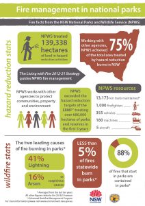
Fact Sheet – Fire Management in National Parks