Bushfire-prone land maps are required to be prepared under section 10.3 of the Environmental Planning and Assessment Act 1979. They are used under the Act to determine which development applications require assessment under the NSW Rural Fire Service’s Planning for Bushfire Protection Guideline.
The NSW Rural Fire Service (RFS) has changed how bushfire-prone land maps are produced and now includes a third category of bushfire hazard, which includes grasslands comprising of grazing and cropping lands, including sugar cane. The RFS provided Council with a Draft Bushfire Prone Land Map based upon the new mapping guideline. Council worked with the RFS to review and improve the map’s accuracy, producing the Draft Richmond Valley Council Bushfire Prone Land Map (dated 2 December 2024).
Please note the updated Bushfire Prone Land Mapping Guide (September 2024) is with the Commissioner of the NSW Rural Fire Service, and approval is expected shortly.
The key changes in the mapping guide (from the 2015 version) include:
- Updated definitions and glossary for better clarity and alignment with the planning system. Notably, some agricultural areas are now classified as bushfire prone, a shift from the 2006 and 2015 guides.
- Revisions to the introduction and legislation sections to reflect current laws and legislative requirements.
- Simplified steps for preparing a Bushfire Prone Land Map, including the addition of Keith Vegetation Formations to clarify vegetation categories.
Vegetation categories and exclusions
Vegetation is identified and determined in accordance with the appropriate vegetation types (Keith, 2004) for all land within the LGA including both private and public land. Vegetation is then classified into the Australian Standard (AS) 3959:2018 Construction of buildings in bushfire-prone areas categories based on vegetation formation and potential hazards.
The bushfire-prone land vegetation categories used for the draft map are described in Table 2.
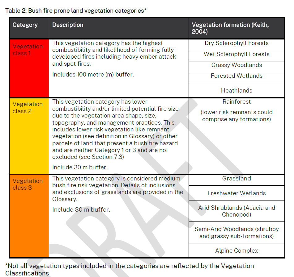
There are several exclusions that apply to bushfire-prone land mapping which include:
− Single areas of vegetation less than one hectare in area and greater than 100 metres separation from other areas of Category 1, 2 or 3 vegetation.
− Multiple areas of vegetation less than 0.25 hectares in area and not within 20 metres of each other.
− Strips of vegetation less than 20 metres in width, regardless of length and not within 20 metres of other areas of Category 1, 2 or 3 vegetation.
− Areas of “managed grassland” including grassland on, but not limited to, recreational areas, commercial/industrial land, residential land, airports/airstrips, maintained public reserves and parklands, commercial nurseries.
− Areas of managed gardens and lawns within curtilage of buildings.
− Non-vegetated areas, including waterways, exposed beaches, roads, footpaths, buildings and rocky outcrops.
− Managed botanical gardens.
− Land used for orchards, vineyards, market gardens, nurseries.
− Saline wetlands including mangroves unless dominated by sedges or other flammable vegetation.
− Other areas that, due to their size, shape and overall risk, are not considered Category 1, 2 or 3 vegetation.
This draft map is now being publicly displayed to alert residents and landowners to pending changes to the mapping. Feedback and comments received during the exhibition will be considered by Council and forwarded to the Commissioner of the NSW Rural Fire Service for consideration before certification of the map. Once certified, the new map becomes effective immediately and replaces the Richmond Valley Council LGA Bushfire Prone Land Map (17 Feb 2015).
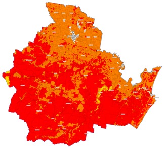
Figure 1 – Draft Richmond Valley Council Bushfire Prone Land Map (2 Dec 2024)
The Draft Bushfire Prone Land Map is being publicly displayed until COB Monday, 31 March 2025. The draft map may be inspected at the Council’s Customer Experience Centres in Casino and Evans Head and online via the On Exhibition page of the Council’s Website, including the Council’s online Mapping tool (click the Public – Planning module, and tick DRAFT – Bush Fire Prone Land Map).
Any person may make written submissions during the exhibition period by addressing them to the General Manager:
- Richmond Valley Council, Locked Bag 10, CASINO NSW 2470, or
- by email to council@richmondvalley.nsw.gov.au or
- by completing an online submission form via the On Exhibition page
Where a submission is by way of objection, the reasons for the objection must be explained.
Notes. All submissions will be treated as public documents.
Further information on the Draft Map is available from Council on (02) 6660 0300.